Before You Begin:
The City of Hollister has released its draft 2040 general plan. The general plan has been a local hot topic and was the subject of a recent referendum. The item of controversy, the expansion of the sphere of influence, is still occurring, albeit on a much smaller scale and only in one area. We’ve highlighted some of the major changes and notable additions from previous drafts. All general plan update documents and feedback can be provided at hollister2040.org
Below are a few definitions to know before reading. Keep in mind, this is a growth plan and not referencing a specific project. There’s quite a bit of information here, so be sure to take your time or grab some coffee!
General Plan: The General Plan is a city or county’s long-term blueprint that sets the overall vision for how land will be used, how much can be built, and where growth should (and shouldn’t) happen over the next 20–30 years.
Specific Plan: A Specific Plan is a detailed rulebook for one defined area that translates the General Plan into exact standards, such as allowed uses, building sizes, street layouts, infrastructure, and development timing, so projects are coordinated rather than piecemeal.
Sphere of Influence: A Sphere of Influence is a boundary adopted by Local Agency Formation Commission that shows where a city is expected to grow and eventually provide services in the future, even if that land is currently outside city limits. A sphere of influence is not city limits.
Sphere of Influence Updates
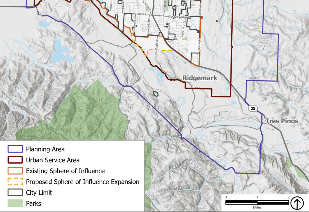
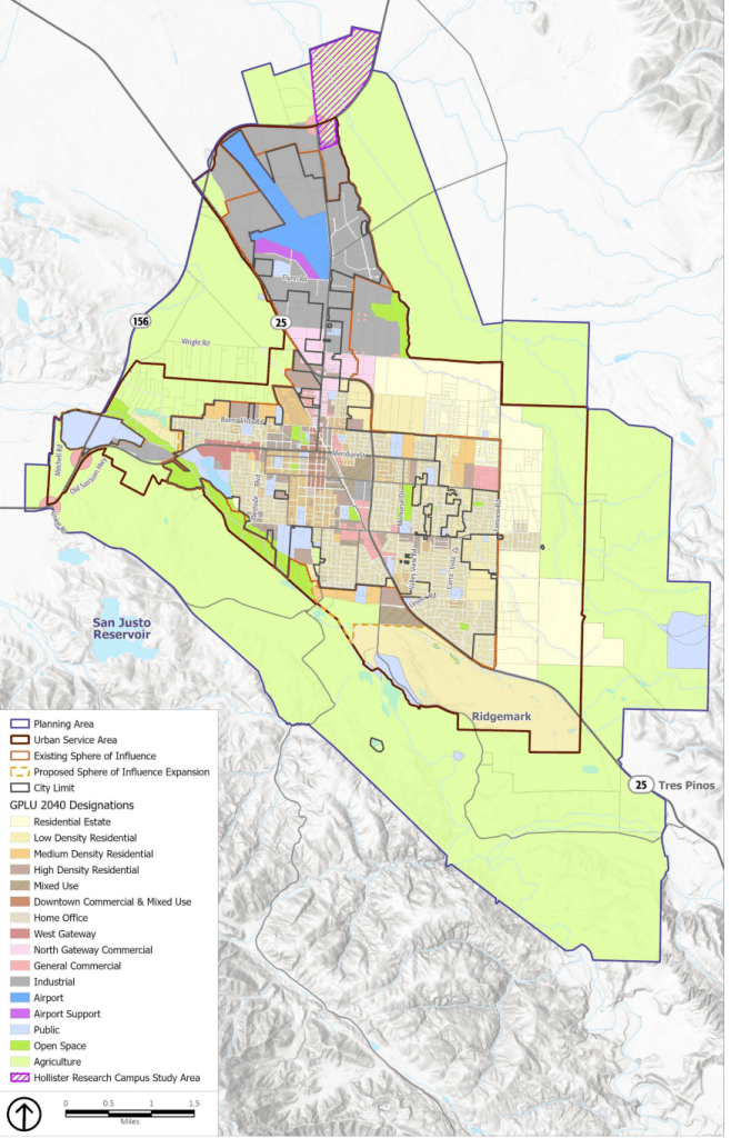
The largest difference in this version of the Hollister general plan is the change to the sphere of influence. Gone is the Buena Vista sphere expansion, the East Hollister sphere expansion, and a portion of the Meridian Street extension. Still included, however, is the Union Road Corridor sphere of influence expansion, which would extend Hollister’s southern sphere of influence to Enterprise Road. This would include both sides of Union Road between the San Benito River and Highway 25.
Special Planning Areas
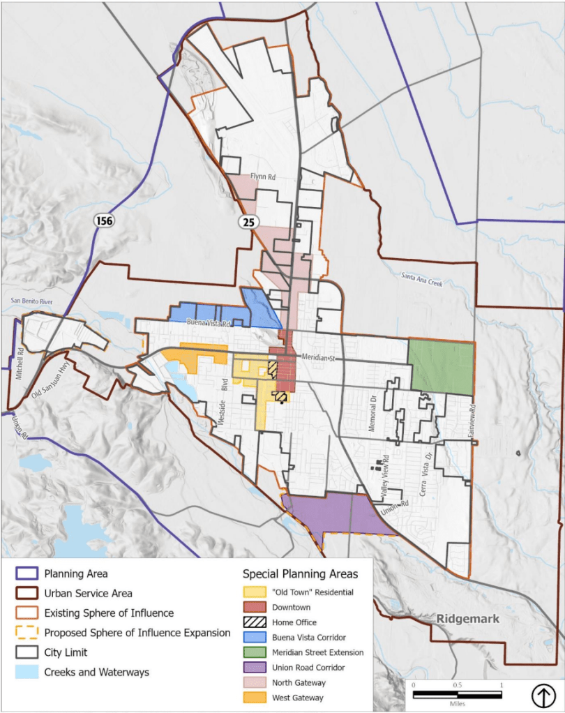
The city has included several special planning areas in this update, we’ve highlighted a few of note.
West Gateway
The orange on the map above includes the area along 4th Street between Graf Road and Westside Boulevard. The plan includes items such as requiring all new buildings built on 4th street be 3 stories, requiring ground-floor commercial usage at Graf, Rajkovich, and Westside Boulevard. It also includes requirements for new public spaces and beautification to be paid for by project developers.
Meridian Street Extension
The Meridian Street Extension references the area in green above bordered by Fairview Road to the east, Santa Ana Road to the north, and Hilcrest Road to the south. As referenced in the name would involve extending Meridian Street to Fairview Road. This area would require a specific plan prior to any development taking place. This would allow the city to plan for infrastructure improvements and a coordinated street network. Of note in this area is the city marking the land for commercial/retail uses. The size of the commercial space would be roughly three times the size of the Hollister Farms shopping area. While the rest of the space would be dedicated to housing. Policies included in the expansion are additions to the city’s bike network and having the city identify means to pay for a bridge for Meridian Street over a creek.
Union Road Corridor
The Union Road corridor is referenced to the city’s proposed sphere of influence expansion (in purple above), which would bring the city’s sphere of influence south to Enterprise Road. This area would also include the requirement for a specific plan before any development was built. The land is currently marked for high density (think apartments) and mixed use to allow for commercial and/or housing.
Planning for Infrastructure Upgrades
The document also includes a plan for the city’s infrastructure. Policies like which roads to widen, implementing the San Felipe beautification plan, relying on roundabouts where possible, and notably a study for improvements to the city’s wastewater treatment plant.
Where To View and Upcoming City Meetings
All General Plan Documents and Comments can be submitted at the city’s website www.hollister2040.org
The Planning Commission will hold a hearing on the general plan:
March 26th, 2026 at 6pm at the Hollister City Council Chambers (City Hall)
The Hollister City Council will hold a hearing on the general plan:
April 20th, 2026 at 6:30p, at the Hollister City Council Chambers (City Hall)

Leave a comment